I have a collection of images of tablets, signposts and way markers that provides a varied and interesting perspective to the history of the Raj.
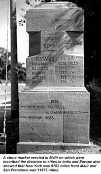
Most cantonments had way markers constructed in stone indicating distances to various cities. I have already mentioned about a way marker in Malir Cantonment in a previous article that gave the distances in miles to Baghdad (1465) and London (6093). The distances to New York (0782), San Francisco via the Pacific route (11875) and Warsaw (3083) were probably added during the Second World War when the cantonment became a major US base to support the China-Burma-India (CBI) Theatre, and also accommodated Polish refugees.
A way marker that has been preserved on the Rawalpindi Mall indicates distances (now converted into kilometres) to various cities to the northwest along and astride the Grand Trunk Road and also to destinations like the valleys of Abbottabad, Kaghan and Kashmir. However, one that I remember from my childhood at the nearby Chaklala Garrison, has sadly been demolished. Fortunately, a way marker with very interesting inscriptions has been preserved at Sialkot Cantonment. It was established in 1852 and by the 1920s it was fairly large with a length of 4km and a width of 2km. During this period, the garrison consisted of the 2nd (Sialkot) Cavalry Brigade, an infantry
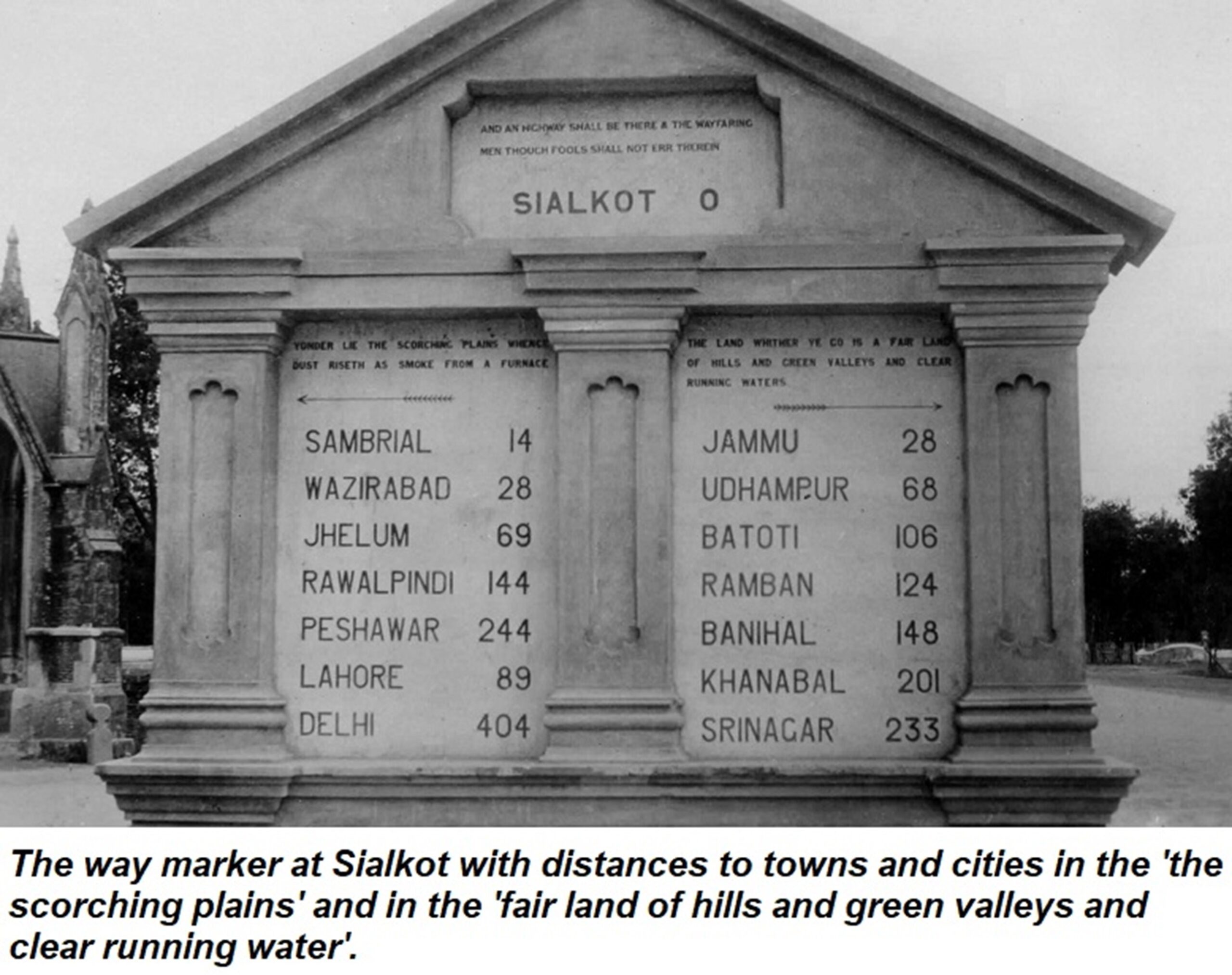
brigade of one British and two native battalions, a battery of horse artillery, engineers and transport units. The inscription on the top of the way marker is a quote from the Bible – ‘And a highway shall be there and the wayfaring men though fools shall not err therein’. The highway refers to the path to the Almighty and warns that it is not for sinners to traverse. The inscription on the left over the distances to Delhi, Lahore, Peshawar, etc. states, ‘Yonder lies the scorching plains whence dust riseth like smoke from a furnace’. On the right are the distances to Ramban, Banihal, and onwards to the beautiful Valley of Kashmir reads. The inscription above reads, ‘The land wither thee go is a fair land of hills and green valleys and clear running water.’
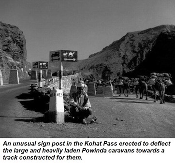
From Bannu the road led to Kohat and onwards to Peshawar through the narrow confines of the Kohat Pass locally known as Darra Adam Khel (the pass of the Adam Khel Afridis). Prior to Independence, caravans of Powindas (a large nomad tribe) seasonally migrated from and to the Afghan Plateau. To ensure that their large caravans of camels and donkeys laden with goods for trading, did not block motor traffic through the pass, somewhat unusual sign posts were erected to deflect the caravans towards tracks constructed for them. The picture was taken sometime around the Second World War and shows the tank obstacles on the road that were constructed against a Soviet invasion that was deemed credible after the Russo-German Treaty (also known as the Molotov–Ribbentrop Pact) in 1939. Tank obstacles called Dragon Teeth still exist in the narrowest confines of the Khyber Pass around Ali Masjid.
The most strategic and famous pass in undivided India was the Khyber Pass which led into Afghanistan. Unlike the present, the border crossing at Torkhum on the western end of the pass, was a simple affair with just a barrier and guard posts. A boundary pillar marked the limit of British India and a notice board warned travellers to comply with passport regulations before they crossed.
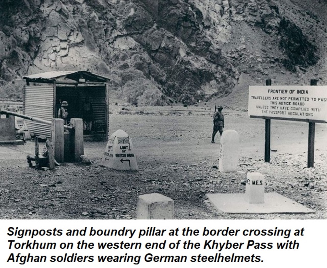
The Afghans guarding the border crossing in the photograph look like Germans soldiers in their unmistakable helmets. In fact, after the Second World War, the Afghan Army was equipped with discarded German equipment including small arms. Even till the 1990s, an interested buyer at the arms market at Darra Adam Khel could purchase a range of German small arms including MP38s and MP40s submachine guns, 8mm Gewehr Rifles, 7.63mm Mauser and 9mm Lugar Pistols.
British battalions serving in the garrisons in the Northwest Frontier, had a tradition of carving their badges on rock faces. While driving to Swat in the 1960s, I remember a number of them at the top of the Malakand Pass but they were destroyed when the road was expanded.
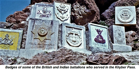
Fortunately, they are still preserved at some locations including the small h ill station of Cherat and within the Khyber Pass. Closer towards Landikotal there is a group of around 15 badges which includes the Middlesex Regiment (1925), Gordon Highlanders (1931-32), 1st Battalion 22nd Cheshire Regiment (1933), 5th Battalion Borders Regiment (1933-34), the Dorsetshire Regiment (1935-37) and the 1st Battalion Queen’s Royal Regiment (1941-42). Some of the Indian battalions also carved their badges – 4/12th Frontier Force Rifles (Charwinjah) (1937-39), 1st Battalion Bahawalpur Regiment and one from the Punjab Regiment. The tradition continued after Independence.
Finally, one lone tablet that stands in a Military Farm near Okara deserves a mention because it is directly linked to the system of the irregular Silladar Regiments that prevailed in the British Indian Cavalry after the revolt of 1857. Their troopers were called Silladars (a Persian word meaning “bearer of arms”), who were issued weapon and ammunition but had to arrange for their horse, stabling attendant, forage, camp equipment and uniform for which they were entitled to a higher pay than his equivalent in the regular regiments. The system was modified in second half of the 19th century and regiments started providing recruits with a horse, equipment and uniforms for their value in money.
During the Second China War in 1860, the 11th King Edward’s Own Lancers (Probyn’s Horse), a Silladar cavalry regiment, established a China Fund subscribed to by the men. The sale of the loot was added to this money. On its return, Colonel Dighton Probyn, the commanding officer used the fund to establish a stud farm and
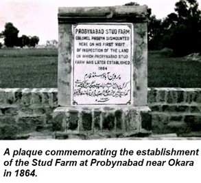
personally selected 1200 acres near Okara. The first Arab stallion at the stud was Probyn’s own charger, Clear-the-Line, and the farm was subsequently named Probynabad. This was replicated by many other Silladar regiments on a lesser scale to rear mounts for the unit and also sell them to the army which generated a good income. Probynabad enjoyed a long excellence in mounts and till the cavalry was mechanised, it reared over 2000 horses. After Independence the land was taken over by the Pakistan Army.