NEITHER FREEDOM NOR SALT
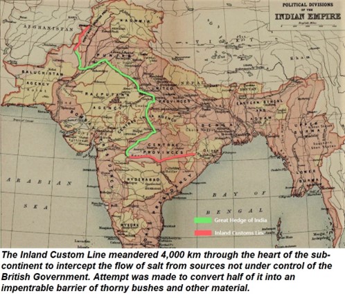
The Northwest Frontier The Three Swords of Meer Jaffir (Part 1 & Part 2) Gun Running to the Northwest Frontier A Tale of Subedar Major Mauladad (1822-1890) The Buddhist Road and The Storming of the Malakand Pass 1895 The Guides Saab Ka Risala 1846-1900 Safe Conduct – A tale about Syed Wazir Ali (Part 1 & Part 2) Under The Raj Revisiting the Great Arc of the Meridian Neither Freedom nor Salt The Lahore Cantonment of Mian Mir Vale Hunting in India and the Peshawar Vale Hunt Feeding the Armies of the Raj Eating Curries in London Signposts, Tablets & Way Markers of the Raj British Indian Army & State Forces Under Pelican Wings— Bahawalpur State Forces On the Departure of Gowhar-i-Taj’s Own Infantry Battalion to Burma. The Irregular Cavalry through the Lens of a Painting The Indian Mountain Artillery Soldiers of the Salt Range Subedar Major Mauladad The Anglo-Sikh Wars Ranjit Singh Ka Topkhana (Part 1, 2 & 3) The Anglo-Sikh Wars & The Battle of Chillianwala Finding Zamzama’s Twin The Death of Capt John Anderson, Bengal Artillery Roads, Railways & Bridges Bridging the Mighty Indus Crossing Rivers in Punjab On the Tracks of the Frontier Mail Pre Independence Personalities Who was Sahabzada Sir Abdus Samad Khan A Gnarled Oak with a Broken Heart Heritage Of Sahabzada Yaqub Dr Khalifa Abdul Hakim – The Islamic Cultural Renaissance Philosopher 24 Marris Road, Aligarh – Dr Abdullah Butt Maj Gen Syed Shahid Hamid An Indian Lieutenant at the 1936 Berlin Olympics The Power of a Mother’s Prayers A Muslim Instructor at Staff College Entering the Hallowed Ranks of the Indian Political Service. Edit Template NEITHER FREEDOM NOR SALT August 27, 2025 Major General Syed Ali Hamid Many of you know about the Trump Wall, an expansion of the Mexico–United States barrier that started during the U.S. presidency of Donald Trump but have you ever heard about the Great Hedge of India – a monstrous undertaking of 4000 km across British India that was officially named the Inland Custom Line. I enjoy reading about the impact that the trade in commodities especially those related to food had on history. The earliest book on this subject that I bought was The Secrets of Saffron (GH-1) which traced the 1,000-year history in Europe of what in the East we call Zafran. I then picked up a fascinating study called The Taste of Conquest (GH- 2) which was about the rise and fall of three great European cities who built their wealth on spices – Venice, Amsterdam and Lisbon. A Brief History of Tea (GH- 3) provided an interesting perspective into the history of the British Empire; and Salt: A World History (GH- 4) showed how this commodity shaped civilization and is a part of the history of humankind. While reading this book, for the first time I became aware of one of the great injustices that the East India Company and its successor, the Government of British India inflicted on its subjects. Salt is an important component of the human diet and has been highly regarded since antiquity. It was an important trading commodity but salt became a strategic mineral as the size of armies (GH-5) began to expand in the West. Armies had to be fed during campaigns and salt was one way of preserving meats and fish – the other was to smoke them. Sources of salt production whether from the sea or land were (GH-6 & 6A) carefully guarded militarily and commercially; tax on salt was an important source of revenue. It also became a source of discord. In France, the salt tax was a significant contributor to the Revolution of 1790 (GH- 7). In British India, the taxes on salt and the restriction on its movement became a symbol of oppression. It was embodied in what was officially called by a variety of names including the Inland Custom Line as well as the pompous-sounding Imperial Custom Line but history remembers it as The Great Hedge of India or just the Indian Salt Hedge. There were four main salt-producing areas (GH-8) in the Indian Subcontinent – the coastal belts of Orissa and the Rann of Kutch for harvesting salt from the sea, the Mandi district of Himachal Pradesh, and the Salt Range extending across the Indus towards Kohat for rock salt. When the East India Company gained control of Bengal and Oudh, trading in salt from Orissa became a monopoly of the senior officers of the company who secured contracts to deliver salt to depots. Such depots were the only way the merchants had to buy salt legally and administrators like Clive (GH- 9) and others made fortunes. When it became a scandal of such immense proportions that it was being questioned in the parliament in the UK, the Company revamped the system twice between 1767 and 1780. It divided the infrastructure into agencies, each under the control of an agent and governed by a controller. Within three years, the revenue from salt rose from Rs. 80,000 to over Rs. 6 million (insert in GH-9) which gives an idea of how much money was being shoveled into the private coffers of the officials of the company. However, to further increase its revenue, the company not only sold the salt at high wholesale prices but also taxed it. There is no limit to greed but it has its consequences. The high price of salt which now few could afford, led to increased smuggling, and at the turn of the century, the Company was forced to establish a series of custom posts along the southern boundaries of the Bengal Presidency (GH- 10) which proved to be ineffective. A more effective line developed from a series of custom posts that were installed along the boundaries of the States of Rajputana (insert highlight). in 1823 by the Commissioner of Customs for Agra and a secondary line extended from Allahabad to Nepal (insert highlight). The Custom Line conformed to the boundaries of the Company rule
THE PESHAWAR VALE HUNT
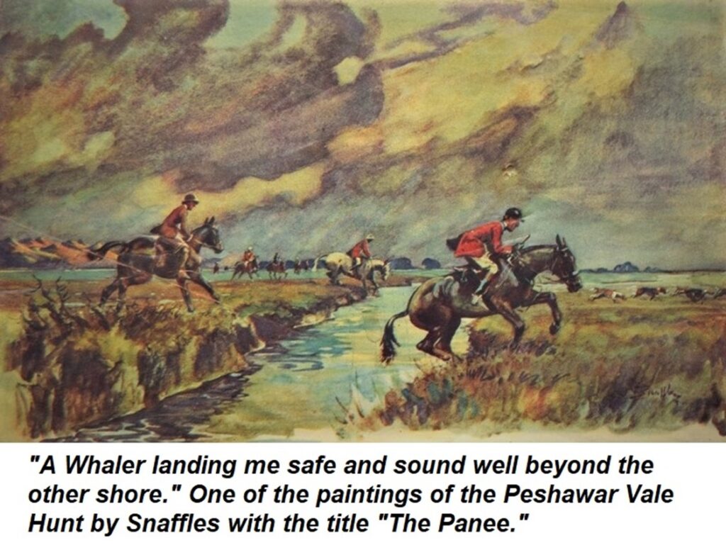
The Northwest Frontier The Three Swords of Meer Jaffir (Part 1 & Part 2) Gun Running to the Northwest Frontier A Tale of Subedar Major Mauladad (1822-1890) The Buddhist Road and The Storming of the Malakand Pass 1895 The Guides Saab Ka Risala 1846-1900 Safe Conduct – A tale about Syed Wazir Ali (Part 1 & Part 2) Under The Raj Revisiting the Great Arc of the Meridian Neither Freedom nor Salt The Lahore Cantonment of Mian Mir Vale Hunting in India and the Peshawar Vale Hunt Feeding the Armies of the Raj Eating Curries in London Signposts, Tablets & Way Markers of the Raj British Indian Army & State Forces Under Pelican Wings— Bahawalpur State Forces On the Departure of Gowhar-i-Taj’s Own Infantry Battalion to Burma. The Irregular Cavalry through the Lens of a Painting The Indian Mountain Artillery Soldiers of the Salt Range Subedar Major Mauladad The Anglo-Sikh Wars Ranjit Singh Ka Topkhana (Part 1, 2 & 3) The Anglo-Sikh Wars & The Battle of Chillianwala Finding Zamzama’s Twin The Death of Capt John Anderson, Bengal Artillery Roads, Railways & Bridges Bridging the Mighty Indus Crossing Rivers in Punjab On the Tracks of the Frontier Mail Pre Independence Personalities Who was Sahabzada Sir Abdus Samad Khan A Gnarled Oak with a Broken Heart Heritage Of Sahabzada Yaqub Dr Khalifa Abdul Hakim – The Islamic Cultural Renaissance Philosopher 24 Marris Road, Aligarh – Dr Abdullah Butt Maj Gen Syed Shahid Hamid An Indian Lieutenant at the 1936 Berlin Olympics The Power of a Mother’s Prayers A Muslim Instructor at Staff College Entering the Hallowed Ranks of the Indian Political Service. Edit Template THE PESHAWAR VALE HUNT August 27, 2025 Major General Syed Ali Hamid Vale Hunting was one of the mounted sports that the British savoured in the sub-continent. There were over 12 hunting clubs in India at Delhi, Meerut, Narbuda Vale, Jaora, Poona, Bombay, Bangalore, Ooty, Madras, Lahore, Quetta and Peshawar. Even Karachi had a hunt club. Madras hosted the earliest hunts but the country was not ideal alternating between the mire of paddy fields during the monsoon and hard dusty plains in winter. Hard and dusty were also the plains where the hunt met around Delhi and Lahore. On the other hand, the Ooty Hunt whose first regular pack was formed in 1869, hunted over the Wenlock Downs; 30 square miles of reserve forest and grazing land described as home country the likes of which no other pack in India can boast. The private Bobbery packs of the 1860s comprising of local dogs were gradually replaced by foxhounds from U.K. Originally ‘couples’ were brought out to India, but they were also later bred in India for the first time in Ooty. Only male hounds were taken out every two or three years to introduce fresh blood. By the late 19 century, regiments and brigades maintained their own packs and some also went to war. During the Second Afghan War, the pack of 16th (The Queen’s) Lancers marched with the regiment from Peshawar to Kabul, and back. Since it was expensive for regiments to maintain their hounds, local hunts were established. Of all the hunts in India, the Peshawar Vale Hunt (P.V.H.) was by far the most famed. The station pack at Peshawar was formed by the Army in 1870 out of the regimental and private packs stationed around Peshawar. The backbone was the purchase of a really level, well-ordered pack of hounds owned by Capt. Markham of the Royal Horse Artillery. At first it was mostly drag hunting in which the hounds followed a scent trail laid by a rider dragging a material soaked in a strong smelling substance. However, as the popularity of the sport grew, the masters went after jacks (short for jackals) and occasionally the small Indian silver fox which afforded little sport as it left very little scent.” Some were of the opinion that the jacks were not as cunning or as fast as the British fox, but an American who rode with the Lahore Hunt during the Second World War, was favourably impressed by its qualities. “The jack in question carried us a good eight miles with ruler precision before hounds came to their noses beside an apparently empty wooden bridge across a dry ditch. The Master cast in all directions and was just about to give up when up popped the jack from a hidden hole in the bank under the bridge. Taking a broken field run that would have done credit to a Notre Dame back-fielder, he zigzagged through the astonished pack and made good his escape. He then led us another five miles in an equally straight line before hounds nabbed him in a brush cutter’s hut and broke him up”. The record of the P.V.H. boasts that “The far-famed Shires of the Eusufzaie Valley have long been acknowledged to be the only real hunting country in India,” and was considered in no way inferior to any in the United Kingdom. The hounds hunted some 400 square miles of fertile land watered by the River Kabul and its tributaries in which the going was generally soft and light, and the scent good. In addition, there were a variety of obstacles to be negotiated including larger water courses, open brooks, dykes and small streams lined with willows. A book titled The P.V.H. published in 1934 provides a wonderful description of “….. the charms of the countryside with its successive changes of scenery as the seasons pass,” and the shires of the Peshawar Vale were sketched by Snaffles the famous artist who partly illustrated the book. Snaffles (Charles Johnson Payne, 1884-1967) was one of the greatest sporting and military artist of his time. He travelled extensively in India and enjoyed a Raj lifestyle with sahibs, polo, shooting, clubs and messes. He also spent a considerable time with the Scinde Horse, from which many of his Indian-period sketches and paintings derive. While travelling in northern India, he stayed with Major Victor
SIGNPOSTS TABLETS & WAY MARKERS
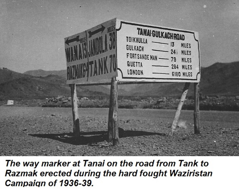
The Northwest Frontier The Three Swords of Meer Jaffir (Part 1 & Part 2) Gun Running to the Northwest Frontier A Tale of Subedar Major Mauladad (1822-1890) The Buddhist Road and The Storming of the Malakand Pass 1895 The Guides Saab Ka Risala 1846-1900 Safe Conduct – A tale about Syed Wazir Ali (Part 1 & Part 2) Under The Raj Revisiting the Great Arc of the Meridian Neither Freedom nor Salt The Lahore Cantonment of Mian Mir Vale Hunting in India and the Peshawar Vale Hunt Feeding the Armies of the Raj Eating Curries in London Signposts, Tablets & Way Markers of the Raj British Indian Army & State Forces Under Pelican Wings— Bahawalpur State Forces On the Departure of Gowhar-i-Taj’s Own Infantry Battalion to Burma. The Irregular Cavalry through the Lens of a Painting The Indian Mountain Artillery Soldiers of the Salt Range Subedar Major Mauladad The Anglo-Sikh Wars Ranjit Singh Ka Topkhana (Part 1, 2 & 3) The Anglo-Sikh Wars & The Battle of Chillianwala Finding Zamzama’s Twin The Death of Capt John Anderson, Bengal Artillery Roads, Railways & Bridges Bridging the Mighty Indus Crossing Rivers in Punjab On the Tracks of the Frontier Mail Pre Independence Personalities Who was Sahabzada Sir Abdus Samad Khan A Gnarled Oak with a Broken Heart Heritage Of Sahabzada Yaqub Dr Khalifa Abdul Hakim – The Islamic Cultural Renaissance Philosopher 24 Marris Road, Aligarh – Dr Abdullah Butt Maj Gen Syed Shahid Hamid An Indian Lieutenant at the 1936 Berlin Olympics The Power of a Mother’s Prayers A Muslim Instructor at Staff College Entering the Hallowed Ranks of the Indian Political Service. Edit Template SIGNPOSTS TABLETS & WAY MARKERS August 27, 2025 Major General Syed Ali Hamid I have a collection of images of tablets, signposts and way markers that provides a varied and interesting perspective to the history of the Raj. Most cantonments had way markers constructed in stone indicating distances to various cities. I have already mentioned about a way marker in Malir Cantonment in a previous article that gave the distances in miles to Baghdad (1465) and London (6093). The distances to New York (0782), San Francisco via the Pacific route (11875) and Warsaw (3083) were probably added during the Second World War when the cantonment became a major US base to support the China-Burma-India (CBI) Theatre, and also accommodated Polish refugees. A way marker that has been preserved on the Rawalpindi Mall indicates distances (now converted into kilometres) to various cities to the northwest along and astride the Grand Trunk Road and also to destinations like the valleys of Abbottabad, Kaghan and Kashmir. However, one that I remember from my childhood at the nearby Chaklala Garrison, has sadly been demolished. Fortunately, a way marker with very interesting inscriptions has been preserved at Sialkot Cantonment. It was established in 1852 and by the 1920s it was fairly large with a length of 4km and a width of 2km. During this period, the garrison consisted of the 2nd (Sialkot) Cavalry Brigade, an infantry brigade of one British and two native battalions, a battery of horse artillery, engineers and transport units. The inscription on the top of the way marker is a quote from the Bible – ‘And a highway shall be there and the wayfaring men though fools shall not err therein’. The highway refers to the path to the Almighty and warns that it is not for sinners to traverse. The inscription on the left over the distances to Delhi, Lahore, Peshawar, etc. states, ‘Yonder lies the scorching plains whence dust riseth like smoke from a furnace’. On the right are the distances to Ramban, Banihal, and onwards to the beautiful Valley of Kashmir reads. The inscription above reads, ‘The land wither thee go is a fair land of hills and green valleys and clear running water.’ The way marker at Tanai on the road from Tank to Razmak was erected during the hard fought Waziristan Campaign of 1936-39. Wazirs, Mahsuds, Bettanis, and even Afghans from across the border rallied to the call for insurrection by Mirzali Khan, more commonly known as the Faqir of Ipi. They were well armed captured mountain guns and with modern rifles mostly smuggled through the Gulf. Apart from many brigades of infantry and batteries of mountain artillery that were required to subdue the revolt, the British had to also employ two companies of tanks and six aircraft squadrons. Towards the east the way marker points towards Jandola and further to Tank which was one of the bases for the campaign. The other base was at Bannu. To the north it points towards Wana and Razmak which were established as permanent garrisons after an earlier campaign in 1919–20. The British strongly associated Razmak with the romance of the Frontier and because of its weather and beautiful surroundings called it Little London. Towards the south the way marker points towards Fort Sandeman which was constructed in 1890 and named after Robert Sandeman, who was the agent to the governor general of Balochistan. Quetta was 284 miles and with a sense of nostalgia, the distance to London (6180 miles) had also been recorded. From Bannu the road led to Kohat and onwards to Peshawar through the narrow confines of the Kohat Pass locally known as Darra Adam Khel (the pass of the Adam Khel Afridis). Prior to Independence, caravans of Powindas (a large nomad tribe) seasonally migrated from and to the Afghan Plateau. To ensure that their large caravans of camels and donkeys laden with goods for trading, did not block motor traffic through the pass, somewhat unusual sign posts were erected to deflect the caravans towards tracks constructed for them. The picture was taken sometime around the Second World War and shows the tank obstacles on the road that were constructed against a Soviet invasion that was deemed credible after the Russo-German Treaty (also known as the Molotov–Ribbentrop Pact) in 1939. Tank obstacles called Dragon Teeth still exist in the narrowest confines of