EPIDEMIC LHR MIAN MIR CANTT
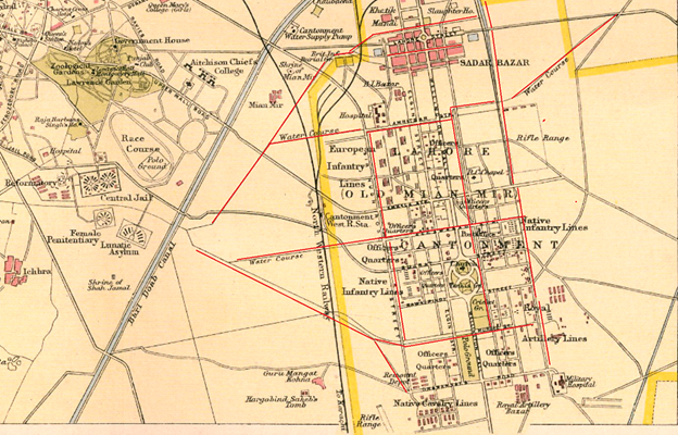
The Northwest Frontier The Three Swords of Meer Jaffir (Part 1 & Part 2) Gun Running to the Northwest Frontier A Tale of Subedar Major Mauladad (1822-1890) The Buddhist Road and The Storming of the Malakand Pass 1895 The Guides Saab Ka Risala 1846-1900 Safe Conduct – A tale about Syed Wazir Ali (Part 1 & Part 2) Under The Raj Revisiting the Great Arc of the Meridian Neither Freedom nor Salt The Lahore Cantonment of Mian Mir Vale Hunting in India and the Peshawar Vale Hunt Feeding the Armies of the Raj Eating Curries in London Signposts, Tablets & Way Markers of the Raj British Indian Army & State Forces Under Pelican Wings— Bahawalpur State Forces On the Departure of Gowhar-i-Taj’s Own Infantry Battalion to Burma. The Irregular Cavalry through the Lens of a Painting The Indian Mountain Artillery Soldiers of the Salt Range Subedar Major Mauladad The Anglo-Sikh Wars Ranjit Singh Ka Topkhana (Part 1, 2 & 3) The Anglo-Sikh Wars & The Battle of Chillianwala Finding Zamzama’s Twin The Death of Capt John Anderson, Bengal Artillery Roads, Railways & Bridges Bridging the Mighty Indus Crossing Rivers in Punjab On the Tracks of the Frontier Mail Pre Independence Personalities Who was Sahabzada Sir Abdus Samad Khan A Gnarled Oak with a Broken Heart Heritage Of Sahabzada Yaqub Dr Khalifa Abdul Hakim – The Islamic Cultural Renaissance Philosopher 24 Marris Road, Aligarh – Dr Abdullah Butt Maj Gen Syed Shahid Hamid An Indian Lieutenant at the 1936 Berlin Olympics The Power of a Mother’s Prayers A Muslim Instructor at Staff College Entering the Hallowed Ranks of the Indian Political Service. Edit Template THE EPIDEMIC IN THE LAHORE CANTONMENT OF MIAN MIR 1850-1906 August 8, 2025 Major General Syed Ali Hamid When Lahore was occupied in 1846, the British and Native troops encamped outside the walled city in the area known as Anarkali. This was a dangerous environment and there was a high mortality rate from gastro-intestinal diseases in the six years that the troops lived here. The average death rate commencing from 1846 was 84.61 per 1,000 i.e. nearly 10 percent. Some battalions lost up to 218.6 per thousand implying that every year two fresh companies had to be dispatched from England to replace the casualties in each British battalion. This forced a decision to construct a new cantonment away from the city. A new cantonment which could handle a large body of troops made sense from a military perspective. Lahore was an important communication center with road and railway links east to Delhi, southwest to Multan, Sukkur and Quetta, and northwards to Rawalpindi and the northwest frontier of British India. It was a timely decision to construct the Mian Mir Cantonment because the Cis-Jhelum division had been re-designated as the Lahore Division. Till the Kitchener Army Reforms of 1905, divisions were not tactical field formations but administrative organizations controlling the brigades and stations in their area. The Lahore Division absorbed the Lahore Field Force under Brigadier Sir James Tennant, which had formed part of the Army of the Punjab since 1847. A large force of one British and five Native battalions, two irregular cavalry units including Skinner’s Horse and a large compliment of artillery were to be stationed at the new cantonment. Another heavy brigade of the division was located at Wazirabad and a lighter one at Sialkot. There are a few stories associated with the selection of the site for the new cantonment by the C-in-C, Sir Charles Napier. The most improbable was that he fell off his horse near the shrine of the Mian Mir and selected the site. Mian Mir, which earlier bore the name of Haslimpur, was located in an open and arid plain, bare of trees. Prince Dara Shikoh, brother of Aurangzeb, who was put to death when the emperor ascended the throne, was a disciple of a famous saint Mullan Shah, known as Mian Mir. He purchased the village of Haslimpur, and bestowed it on his religious preceptor, after whom it was renamed. The author William J. Glover provides a very descriptive account of the planning and layout of the cantonment at Mian Mir. ‘Military engineers …. designed its roads and fences, parade ground, rifle range, polo and cricket grounds, the British and Native infantry barracks, officers’ quarters, slaughter house, cavalry lines, Royal Artillery Lines and Native bazars; they laid out the sites for a Roman Catholic Chapel, post office, the British and Native hospitals and – in a neo-classical flourish– the oval shaped park at Mian Mir’s center.’ However, Lt. Col. Rowan, of the Royal Army Medical Corps who spent three years in Mian Mir from 1903-06, and wrote an article for a medical journal was of the opinion that, “It is a long straggling cantonment, laid out on a much larger scale than has ever been found to be necessary”. According to the author, “Senior officers lived near the center of the cantonment, and subordinate personnel were placed outward from the center in order of decreasing rank. Native and European troops occupied separate quarters, and each group was housed according to their rank in identical barracks grouped together in blocks of parallel lines”. I would differ with the author on British and Native troops in identical accommodation. The British troops in India lived in barracks which provided much better living conditions than the Lines in which the Native sepoys were accommodated. Right till Independence, the lines for Native sepoys had no electricity. The barracks at Mian Mir were planned by Sir Charles Napier, and in point of general arrangement, accommodation, lighting, etc., were a long way in advance of any barracks at the time. The major north-south roads were named after stalwarts of the empire i.e. Elgin Street, Wellington Mall, etc. and the minor east-west streets were named after the towns & cities in the new province e.g. Amritsar Street, Gujrat Street, etc. The Native Cavalry Lines were at the southern end of the cantonment and the open space
REVISITING THE GREAT ARC OF THE MERIDIAN
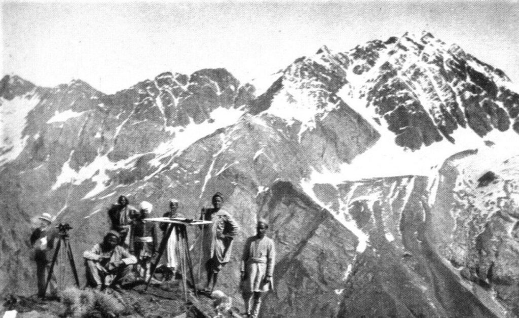
The Northwest Frontier The Three Swords of Meer Jaffir (Part 1 & Part 2) Gun Running to the Northwest Frontier A Tale of Subedar Major Mauladad (1822-1890) The Buddhist Road and The Storming of the Malakand Pass 1895 The Guides Saab Ka Risala 1846-1900 Safe Conduct – A tale about Syed Wazir Ali (Part 1 & Part 2) Under The Raj Revisiting the Great Arc of the Meridian Neither Freedom nor Salt The Lahore Cantonment of Mian Mir Vale Hunting in India and the Peshawar Vale Hunt Feeding the Armies of the Raj Eating Curries in London Signposts, Tablets & Way Markers of the Raj British Indian Army & State Forces Under Pelican Wings— Bahawalpur State Forces On the Departure of Gowhar-i-Taj’s Own Infantry Battalion to Burma. The Irregular Cavalry through the Lens of a Painting The Indian Mountain Artillery Soldiers of the Salt Range Subedar Major Mauladad The Anglo-Sikh Wars Ranjit Singh Ka Topkhana (Part 1, 2 & 3) The Anglo-Sikh Wars & The Battle of Chillianwala Finding Zamzama’s Twin The Death of Capt John Anderson, Bengal Artillery Roads, Railways & Bridges Bridging the Mighty Indus Crossing Rivers in Punjab On the Tracks of the Frontier Mail Pre Independence Personalities Who was Sahabzada Sir Abdus Samad Khan A Gnarled Oak with a Broken Heart Heritage Of Sahabzada Yaqub Dr Khalifa Abdul Hakim – The Islamic Cultural Renaissance Philosopher 24 Marris Road, Aligarh – Dr Abdullah Butt Maj Gen Syed Shahid Hamid An Indian Lieutenant at the 1936 Berlin Olympics The Power of a Mother’s Prayers A Muslim Instructor at Staff College Entering the Hallowed Ranks of the Indian Political Service. Edit Template REVISITING THE GREAT ARC OF THE MERIDIAN August 8, 2025 Major General Syed Ali Hamid One of my endearing memories is standing in the cupola of the tank talking on the wireless set with a mug of tea in one hand and a map in the other. All three were indispensable but the map was also my friend. It told me where I was and how to get to my destination. It told me what features the ‘enemy’ could defend and how best to approach them without exposing my tanks. It also told me where there was a clump of trees to conceal my troops and the names of all the villages in the area. With the grids on the map I could register the ‘enemies’ location which the aircraft and artillery could engage with accuracy. The map we were taught to ‘read’ at the military academy had a scale of one-inch i.e. an inch on the map corresponded to 1000 yards on the ground. Therefore, it contained detailed information e.g. single huts, lone trees, contours spaced out at a 100 yards – in short all the necessary information for the commanders and troops of a tactical units within an accuracy of 6 yards. If you look closely at a one-inch map sheet, at varying intervals you will see a small triangle with a number e.g. 556. The triangle is the symbol for a triangulation (trig) point (usually marked on ground by a concrete or stone pillar) and the number denotes its height. They are always located at the highest point in the surrounding area from where one or more trig points can be observed with a theodolite – a precision instrument for measuring angles in the horizontal and vertical planes. Trig points form a network of triangulation based on which a follow-up topographical survey accurately establishes the exact positions of villages & town, boundaries, roads, railways, bridges, etc. across the entire country. Therefore, the trig points lie at the heart of accurate mapping which in the subcontinent commenced 218 years ago in 1802. For the next 80 years, London did not have any Indian restaurants worth their name but things started changing in the twentieth century. Salut e Hind was the first to open in Holborn in 1911, followed by The Kohinoor’ in Roper Street, and Curry Café on Commercial Street in the 1920s. The Kohinoor did remarkably well and the three Bahadur brothers from Delhi opened more branches of Kohinoor in Cambridge and Manchester and the Taj Mahal in Brighton; Oxford and Northampton and all before the outbreak of the Second World War. Ten years ago I chanced upon a book in a second hand store that I now treasure. It’s called The Great Arc and is about the largest land survey attempted in the world. It was initiated by the Madras Presidency in 1802 and taken up by the Presidencies of Bombay and Bengal. The architect behind this idea was William Lambton, a British officer who displayed his survey skills by navigating by stars during the Fourth Anglo-Mysore War. His proposal for conducting a survey of the territories captured by the British in Southern India were supported by Major General Arthur Wellesley (later the Duke of Wellington) and approved by Robert Clive. As the shadow of the East India Company spread over the subcontinent, so did this great survey and was continued by Sir George Everest and his successor Andrew Waugh. A survey commences with marking and measuring a baseline. From the two terminals of the base line (A&B), the angles and elevation of a third point (C) are measured with a theodolite thus forming a triangle. The length of the sides i.e. the distances AC and BC can be calculated with trigonometry. Line BC forms the next baseline to measure point D and so on. This seemingly simple process is called triangulation. However, the larger the area to be surveyed, the bigger the base line should be and more accurate its measurement.